Street Level Routing
Point to point street routing, Route Matrix determination & Drive Time Polygon determination.
Get Expert Advice on Street Level Routing
4. Street Level Routing: Point to point street routing, Route Matrix determination & Drive Time Polygon determination.
Street Level Routing – returns routing information for a set of two distinct points or for multiple 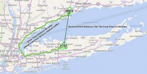 points, either fastest or shortest. Specified road types can be favored, avoided or given different preferences (e.g. high, low, medium.) You have control over speeds used by road type – by percentage or absolute value. Historical traffic speeds can be used (e.g. AMPeak, PMPeak, OffPeak and Night.)
Driving directions can be included and customized. 27 languages are supported.
Route Matrix Determination – calculates the travel time and distances between an array of start and end locations, based on shortest or fastest paths between each of the points. Specified road types can be favored, avoided or given different preferences (e.g. high, low, medium.) You have control over speeds used by road type – by percentage or absolute value. Historical traffic speeds can be used (e.g. AMPeak, PMPeak, OffPeak and Night.)
Drive Time Polygon (Isochrones) – Drive time polygons are shapes created by the time of travel. 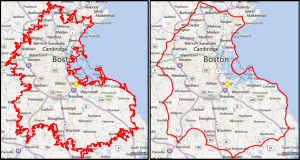 Compare at 10 mile radius around a location vs a 10 minute drive. The radius is obviously a circle but the 10-minute drive takes into account the road network and road speed limits. A drive time shape is rarely a circle. You have control over speeds used by road type – by percentage or absolute value. Historical traffic speeds can be used (e.g. AMPeak, PMPeak, OffPeak and Night.) In some cases, island and donut shapes can be returned. You have the option to control whether these are returned.
Note that, separate from these services, raw street data is available.
You are on the Street-Level Routing Page in the Software-as-a-Service (SaaS) Section….