1-866-846-5900

info@SpatialPoint.com

Address Validation

Physical addresses anchor hundreds of digital data points, which are used in every aspect of organizational decision-making.

They have to be right.

Learn about our software and services to validate and correct your addresses – addresses in the US, Canada and around the world.

In the past, a bad address meant a returned mailer, maybe a failed promotion or loss of a customer.

Today, a bad address can represent fraud or result in the loss of millions of dollars from poorly completed risk assessments or opportunity analyses. Even worse, address issues may show up in regulatory filings that could literally cost you your business. That’s on top of significant additional costs in today’s lightning fast e-commerce industry.

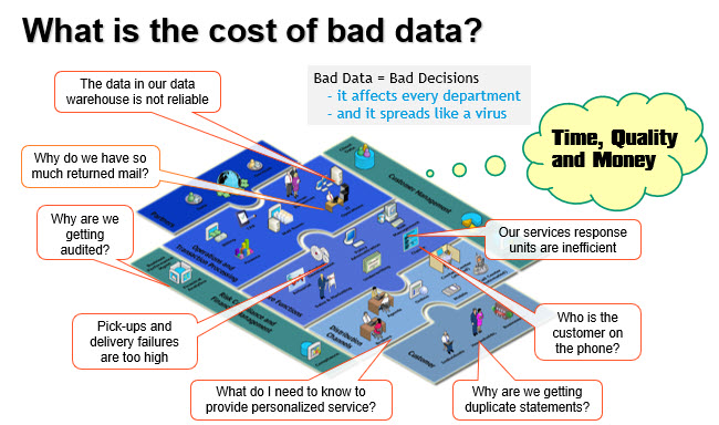
As our reliance on IT grows, the cost of bad location data just keeps getting higher.

And due to the inter-relationships between datasets, bad data multiplies like a virus.

That’s why it is so important to implement Best in Class Address Validation & Correction services at the beginning of your decision-making processes.

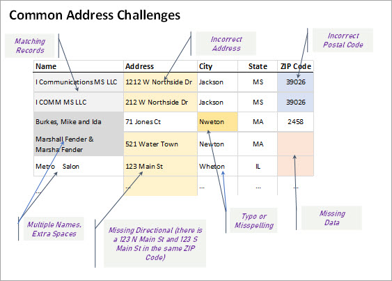
  • Standardize address formats coming from multiple sources.
  • Eliminate duplicate records. Or triplicates.
  • Turn address fragments into complete addresses.
  • Identify multiple customers at the same address.
  • Identify one customer with multiple addresses, and use the right one.
  • Confirm that every address is real and deliverable.
  • If you are geocoding, send the geocoder the correct address–it makes a difference. 

In partnership with Precisely, formally Pitney Bowes Software, a leader in location intelligence for over 30 years, we provide Address Validation & Correction services for more than 240 countries—sometimes from fragments as small as a postal code and PO Box number.

Add VeriMoveTM to your services and you can also stay in touch with the millions of your customers that move each year. This service gives you access to 18-48 months of change of address data.

  • Improve your decision-making ability and business outcomes
  • Save yourself the high cost of bad address data
  • And take full advantage of the unique insights provided by location intelligence based on real, valid addresses:
    • Detecting fraud
    • Identifying consumer trends
    • Analyzing opportunity and risk
    • Developing promotions
    • and Complying with legal regulations

You are on the Address Validation Page in the Software-as-a-Service (SaaS) Section….

[dipi_button_grid flex_direction=”row” _builder_version=”4.16″ _module_preset=”default” text_style_font=”Molengo|||||on|||” text_style_text_align=”center” text_style_font_size=”14px” background_color=”rgba(0,0,0,0)” transform_translate=”0px|-25px” transform_translate_linked=”off” max_height=”306px” custom_margin=”||||false|false” custom_padding=”||||false|false” animation_style=”fade” animation_duration=”400ms” border_color_all=”#edf000″ saved_tabs=”all” locked=”off” global_colors_info=”{}”][dipi_button_grid_child button_id=”SaaS Overview” button_text=”SaaS Overview” button_link=”https://spatialpoint.com/saas-ondemand/” _builder_version=”4.16″ _module_preset=”default” text_style_font=”Molengo|||||on|||” text_style_font_size=”26px” background_color=”rgba(0,0,0,0)” background_enable_color=”on” custom_button=”on” button_text_color=”#ffffff” button_bg_color=”#e02b20″ button_border_color=”#d6d6d6″ button_border_radius=”11px” button_font=”Roboto||||||||” button_use_icon=”on” button_icon=”%%24%%” button_icon_color=”#ffffff” button_on_hover=”on” custom_margin=”|0px|||false|false” custom_padding=”||||false|false” border_width_all=”1px” border_color_all=”rgba(0,0,0,0)” box_shadow_style_button=”preset1″ global_colors_info=”{}”][/dipi_button_grid_child][dipi_button_grid_child button_id=”Geocoding” button_text=”Geocoding” button_link=”https://spatialpoint.com/1-geocoding/” _builder_version=”4.16″ _module_preset=”default” text_style_font=”Molengo|||||on|||” text_style_font_size=”26px” background_color=”rgba(0,0,0,0)” background_enable_color=”on” custom_button=”on” button_text_color=”#ffffff” button_bg_color=”#e02b20″ button_border_color=”#d6d6d6″ button_border_radius=”11px” button_font=”Roboto||||||||” button_use_icon=”on” button_icon=”%%24%%” button_icon_color=”#ffffff” button_on_hover=”on” custom_margin=”|0px|||false|false” custom_padding=”||||false|false” border_width_all=”1px” border_color_all=”rgba(0,0,0,0)” box_shadow_style_button=”preset1″ global_colors_info=”{}”][/dipi_button_grid_child][dipi_button_grid_child button_id=”AddressVal” button_text=”Address Validation & Correction” button_link=”https://spatialpoint.com/address-validation/” _builder_version=”4.16″ _module_preset=”default” text_style_font=”Molengo|||||on|||” text_style_font_size=”26px” background_color=”rgba(0,0,0,0)” background_enable_color=”on” custom_button=”on” button_text_color=”#ffffff” button_bg_color=”#fc9569″ button_border_color=”#d6d6d6″ button_border_radius=”11px” button_font=”Roboto||||||||” button_use_icon=”on” button_icon=”%%24%%” button_icon_color=”#ffffff” button_on_hover=”on” custom_margin=”|0px|||false|false” custom_padding=”||||false|false” border_width_all=”1px” border_color_all=”rgba(0,0,0,0)” box_shadow_style_button=”preset1″ global_colors_info=”{}”][/dipi_button_grid_child][dipi_button_grid_child button_id=”ReverseGeocoding” button_text=”Reverse Geocoding” button_link=”https://spatialpoint.com/3-reverse-geocoding/” _builder_version=”4.16″ _module_preset=”default” text_style_font=”Molengo|||||on|||” text_style_font_size=”26px” background_color=”rgba(0,0,0,0)” background_enable_color=”on” custom_button=”on” button_text_color=”#ffffff” button_bg_color=”#e02b20″ button_border_color=”#d6d6d6″ button_border_radius=”11px” button_font=”Roboto||||||||” button_use_icon=”on” button_icon=”%%24%%” button_icon_color=”#ffffff” button_on_hover=”on” custom_margin=”|0px|||false|false” custom_padding=”||||false|false” border_width_all=”1px” border_color_all=”rgba(0,0,0,0)” box_shadow_style_button=”preset1″ global_colors_info=”{}”][/dipi_button_grid_child][dipi_button_grid_child button_id=”Street-Level Routing” button_text=”Street-Level Routing” button_link=”https://spatialpoint.com/4-street-level-routing/” _builder_version=”4.16″ _module_preset=”default” text_style_font=”Molengo|||||on|||” text_style_font_size=”26px” background_color=”rgba(0,0,0,0)” background_enable_color=”on” custom_button=”on” button_text_color=”#ffffff” button_bg_color=”#e02b20″ button_border_color=”#d6d6d6″ button_border_radius=”11px” button_font=”Roboto||||||||” button_use_icon=”on” button_icon=”%%24%%” button_icon_color=”#ffffff” button_on_hover=”on” custom_margin=”|0px|||false|false” custom_padding=”||||false|false” border_width_all=”1px” border_color_all=”rgba(0,0,0,0)” box_shadow_style_button=”preset1″ global_colors_info=”{}”][/dipi_button_grid_child][dipi_button_grid_child button_id=”InsuranceRisk” button_text=”Insurance Risk Services” button_link=”https://spatialpoint.com/insurance-risk-services/” _builder_version=”4.16″ _module_preset=”default” text_style_font=”Molengo|||||on|||” text_style_font_size=”26px” background_color=”rgba(0,0,0,0)” background_enable_color=”on” custom_button=”on” button_text_color=”#ffffff” button_bg_color=”#e02b20″ button_border_color=”#d6d6d6″ button_border_radius=”11px” button_font=”Roboto||||||||” button_use_icon=”on” button_icon=”%%24%%” button_icon_color=”#ffffff” button_on_hover=”on” custom_margin=”|0px|||false|false” custom_padding=”||||false|false” border_width_all=”1px” border_color_all=”rgba(0,0,0,0)” box_shadow_style_button=”preset1″ global_colors_info=”{}”][/dipi_button_grid_child][dipi_button_grid_child button_id=”PSAP911″ button_text=”911/E911/PSAP” button_link=”https://spatialpoint.com/6-911-e911-psap/” _builder_version=”4.16″ _module_preset=”default” text_style_font=”Molengo|||||on|||” text_style_font_size=”26px” background_color=”rgba(0,0,0,0)” background_enable_color=”on” custom_button=”on” button_text_color=”#ffffff” button_bg_color=”#e02b20″ button_border_color=”#d6d6d6″ button_border_radius=”11px” button_font=”Roboto||||||||” button_use_icon=”on” button_icon=”%%24%%” button_icon_color=”#ffffff” button_on_hover=”on” custom_margin=”|0px|||false|false” custom_padding=”||||false|false” border_width_all=”1px” border_color_all=”rgba(0,0,0,0)” box_shadow_style_button=”preset1″ global_colors_info=”{}”][/dipi_button_grid_child][dipi_button_grid_child button_id=”Tax Jurisdiction ” button_text=”Tax Jurisdiction ” button_link=”https://spatialpoint.com/7-tax-jurisdiction/” _builder_version=”4.16″ _module_preset=”default” text_style_font=”Molengo|||||on|||” text_style_font_size=”26px” background_color=”rgba(0,0,0,0)” background_enable_color=”on” custom_button=”on” button_text_color=”#ffffff” button_bg_color=”#e02b20″ button_border_color=”#d6d6d6″ button_border_radius=”11px” button_font=”Roboto||||||||” button_use_icon=”on” button_icon=”%%24%%” button_icon_color=”#ffffff” button_on_hover=”on” custom_margin=”|0px|||false|false” custom_padding=”||||false|false” border_width_all=”1px” border_color_all=”rgba(0,0,0,0)” box_shadow_style_button=”preset1″ global_colors_info=”{}”][/dipi_button_grid_child][dipi_button_grid_child button_id=”Specialty” button_text=”Specialty” button_link=”https://spatialpoint.com/8-specialty/” _builder_version=”4.16″ _module_preset=”default” text_style_font=”Molengo|||||on|||” text_style_font_size=”26px” background_color=”rgba(0,0,0,0)” background_enable_color=”on” custom_button=”on” button_text_color=”#ffffff” button_bg_color=”#e02b20″ button_border_color=”#d6d6d6″ button_border_radius=”11px” button_font=”Roboto||||||||” button_use_icon=”on” button_icon=”%%24%%” button_icon_color=”#ffffff” button_on_hover=”on” custom_margin=”|0px|||false|false” custom_padding=”||||false|false” border_width_all=”1px” border_color_all=”rgba(0,0,0,0)” box_shadow_style_button=”preset1″ global_colors_info=”{}”][/dipi_button_grid_child][/dipi_button_grid]

More from our Blog…

Geocoding Basics

Geocoding Basics

Geocoding Basics   What is geocoding? Simply, it’s the process of matching a location such as: an address ("Street-level geocoding") postal (ZIP) code ("ZIP-Level or Postal-Level geocoding) city name ("City-Level Geocoding, not used as much anymore) county name,...

Introducing the Signal And Noise Blog – Topics Include Mapping, Spatial, Geocoding, Address Correction, Geographic Data

One of our goals in communicating to you is to provide the most important information that helps you identify the signal and the noise. Think of listening to a radio station with static. The static is the noise and the voices or music are the signal. Our brains do a great job of filtering audio and there are tools to draw out the signal and suppress the noise. This blog is about focusing on the signal for various topics and, when possible, we’ll describe the noise. Unlike the radio static that is random, some of the noise in the marketplace may seem like signal, but it’s not.