[spb_tabs tabs_type=”standard” center_tabs=”no” width=”3/4″ el_position=”first”] [spb_tab title=”Overview” icon=”” id=”Newinv160″] [spb_text_block animation=”none” animation_delay=”0″ simplified_controls=”yes” custom_css_percentage=”no” padding_vertical=”0″ padding_horizontal=”0″ margin_vertical=”0″ custom_css=”margin-top: 0px;margin-bottom: 0px;” border_size=”0″ border_styling_global=”default” width=”1/1″ el_position=”first last”]
MapInfo Professional is a powerful mapping tool and is packed with features to help you to see trends and patterns so you can make informed decisions and develop your business.
[spb_blank_spacer height=”30px” width=”1/1″ el_position=”first last”]
Simple to use and integrate
MapInfo Professional is extremely flexible and can be easily integrated with your current IT systems. It is also extremely user-friendly so you don’t need to be an IT expert to use it.
The familiar ribbon-based interface works just like the applications you use every day. With our intuitive design, you don’t need to be a computer whiz to become a map master.
[spb_divider type=”dotted” full_width=”no” width=”1/1″ el_position=”first last”]
Easily accessible data
MapInfo Professional supports a range of data formats including many common PC file formats (such as Microsoft Excel, Access, DBF and CSV files), relational and spatial database formats (Oracle, Microsoft SQL Server, PostGIS, SQLite and ODBC compliant databases), and spatial data formats ( AutoCAD DXF/DWG, SHP, DGN and more).
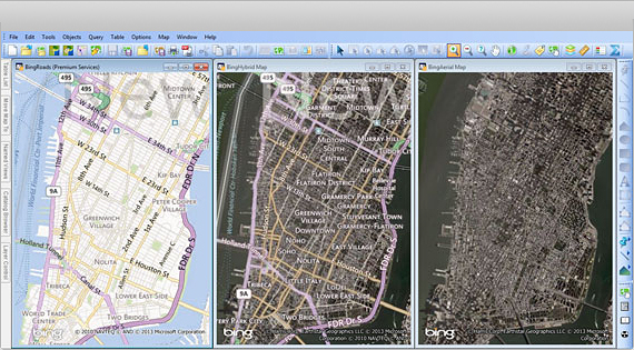
You can also use imagery (aerial images, satellite images, scanned paper maps, etc.) of almost any format in your maps. And MapInfo Professional includes access to Microsoft Bing aerial and hybrid maps as standard.
[spb_blank_spacer height=”30px” width=”1/1″ el_position=”first last”]
[spb_divider type=”dotted” full_width=”no” width=”1/1″ el_position=”first last”]
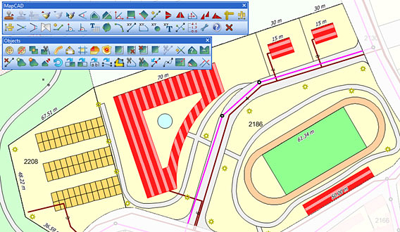
Superb data creation and editing functions
With MapInfo Professional you can access a vast selection of CAD data creation and editing tools as well as edit tabular data like values and names.
MapInfo Professional allows you to make changes to all your maps and data in a single application, saving you time and effort.
[spb_blank_spacer height=”30px” width=”1/1″ el_position=”first last”]
[spb_divider type=”dotted” full_width=”no” width=”1/1″ el_position=”first last”]
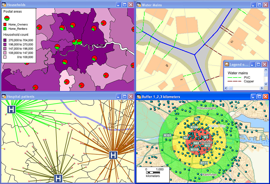
Flexible map display and visualization options
MapInfo Professional’s simple-to-use map display wizards and detailed customization options allow users of all skill levels to create great looking maps quickly. Load image data sets as background mapping and overlay your point, line and polygon data to visualize your data in the way you want. Change the style and appearance of any data set using our powerful analytical processes and display customization techniques.
You can also aggregate values using statistical or any math functions to associate a symbol or colour to a point or a region based on a calculated value. For example, view your sales territories according to the number of customers in each area.
[spb_blank_spacer height=”30px” width=”1/1″ el_position=”first last”]
[spb_divider type=”dotted” full_width=”no” width=”1/1″ el_position=”first last”]
[spb_blank_spacer height=”15px” width=”1/1″ el_position=”first last”]
[sf_button colour=”gold” type=”standard” size=”standard” link=”https://spatialpoint.com/wp-content/uploads/2013/10/MapInfo-Pro-v16-DataSheet-1.pdf” target=”_blank” icon=”” dropshadow=”no” extraclass=””]MapInfo Professional Product Data Sheet[/sf_button] [sf_button colour=”gold” type=”standard” size=”standard” link=”https://spatialpoint.com/wp-content/uploads/2013/10/MapInfo-Professional-Premium.pdf” target=”_blank” icon=”” dropshadow=”no” extraclass=””]MapInfo Professional Premium Services Data Sheet[/sf_button] [sf_button colour=”gold” type=”standard” size=”standard” link=”https://spatialpoint.com/wp-content/uploads/2013/10/MIProv12.5-Creative-Evolution.pdf” target=”_blank” icon=”” dropshadow=”no” extraclass=””]MapInfo Professional Version Comparison[/sf_button]
[/spb_text_block] [/spb_tab] [spb_tab title=”New in v16.0″ icon=”” id=””] [spb_text_block animation=”none” animation_delay=”0″ simplified_controls=”yes” custom_css_percentage=”no” padding_vertical=”0″ padding_horizontal=”0″ margin_vertical=”0″ custom_css=”margin-top: 0px;margin-bottom: 0px;” border_size=”0″ border_styling_global=”default” width=”1/1″ el_position=”first last”]
MapInfo Professional v16.0 makes it easier than ever to create great looking maps. With new cartographic output features such as enhanced automatic labelling options, new scalebar enhancements, and greater flexibility over legend and layout objects, making maps that stand out has never been so easy.
The latest release of the world’s premier desktop mapping and GIS application just got simpler, faster and smarter. Enhanced in so many ways, the newest version of MapInfo Pro software lets you visualize data and capitalize on those insights in less time than ever. It’s never been easier to be more precise, productive and successful.
- New interactive interface for thematic mapping
- On demand access to global geocoding included
- Improved support for OGC standards, including WMTS
- Faster, more intuitive Layout Designer
- Significant raster GIS improvements with MapInfo Pro™ Advanced and much more
- The latest release takes performance further, with improved visualization, analysis and productivity enhancements:
- Support for creating grids from multiple files (including LiDAR/.LAS datasets)
- Additional capabilities in the powerful Grid Calculator
- New grid interpolation methods
Enhancements to the Legend Designer introduced in a previous version provide control over the order of objects within a frame, automatic word wrapping for long text and resizing of style swatches for individual layers. Multiple level undo to Layouts. This means that any number of edits carried out in a layout window can be undone and redone. Objects within the layout window can now be quickly aligned.
[spb_blank_spacer height=”30px” width=”1/1″ el_position=”first last”]
QUICK LOOK: Cartographic output
Cartographic output
Enhancements to the Legend Designer introduced in a previous version provide control over the order of objects within a frame, automatic word wrapping for long text and resizing of style swatches for individual layers. Multiple level undo to Layouts. This means that any number of edits carried out in a layout window can be undone and redone. Objects within the layout window can now be quickly aligned.
[spb_divider type=”dotted” full_width=”no” width=”1/1″ el_position=”first last”]
Ease of use
MapInfo Professional v16.0 continues to be the world’s most powerful easy to use GIS. New tools such as Compare Table Structure which allows users to compare and edit data in multiple tables simultaneously, the new PolyBuilder tool for automatically creating polygons from digitized linework and the new Quick Translator tool for getting non-native data in and out of MapInfo Professional, mean complex operations are made straightforward, saving valuable time.
Technology updates
With support for Windows 10 and Windows Server 2012, MapInfo Professional v16.0 allows organizations to make use of the latest hardware and software available. Users are now also able to read, write and create SQLite databases allowing seamless interoperability with the range of Autodesk products. The inclusion of the new Quick Translator makes getting data in and out of MapInfo Professional easier than ever.
In product notifications
MapInfo Professional v16.0 allows you to keep up-to-date with the latest MapInfo news and events through the inclusion of an in-product notification system. The new reader inside MapInfo Professional will automatically check for and retrieve notifications of important information such as patch releases and updates, thought leadership articles and license expiry notifications.
Features and Capabilities
Create thematic maps with ease. Update your legend and data range bins without leaving your map.
- Interactive and intuitive
- Ribbon-based navigation
- Quick-click dropdowns and rollover displays
- Instant feedback from gallery controls
Customized Experience
- Tailor the ribbon with your own tabs and groups.
- Customize keyboard shortcuts.
- Automate common tasks.
- Build custom solutions with MapBasic.
Total Data Compatibility
MapInfo Pro integrates easily with your existing systems and platforms, supporting a wide range of data and GIS formats.
Common PC files:
- Microsoft® Excel
- Access
- DBF
- CSV and delimited ASCII text files
Relational and spatial databases:
- Oracle®
- Microsoft® SQL Server
- PostGIS
- SQLite
- ODBC compliant databases
Spatial Data:
- AutoCAD® DXF/DWG
- SHP
- DGN
- GML
- KML
- OGC GeoPackage
- And more!
Maps and imagery:
- WMTS (background maps)
- WMS and WFS services
- Aerial images
- Satellite images
- Scanned paper maps
- Microsoft® Bing maps
Data Creation and Editing
Access a vast selection of data creation and editing tools.
- Edit your tabular and spatial data.
- Utilize over 40 CAD-like utilities.
- Make changes to all your maps and data in a single application.
Flexible Visualization Options
Enjoy simple-to-use display wizards and detailed customization options.
- Load raster datasets as background maps.
- Overlay point, line and polygon data.
- Modify the style and look of any dataset using powerful analysis and display techniques.
- Aggregate values using advanced statistical and math functions.
Powerful Raster GIS Analysis
Achieve more with MapInfo Pro Advanced.
- High-resolution grid data of immense size
- Comprehensive visualization options (e.g. analytical hill shading)
- Powerful grid analysis (e.g. slope calculation, line-of-sight analysis)
- Advanced grid analysis using an easy-to-use Grid Calculator
Easy Results Sharing
- Achieve more with MapInfo Pro Advanced.
- Print, publish and share your maps with ease.
- Add legends and charts using our Wizards.
- Share, save or export data in commonly used formats.
- Take fast action from your insights.
[/spb_text_block] [/spb_tab] [spb_tab title=”Specifications” icon=”” id=””] [spb_text_block animation=”none” animation_delay=”0″ simplified_controls=”yes” custom_css_percentage=”no” padding_vertical=”0″ padding_horizontal=”0″ margin_vertical=”0″ custom_css=”margin-top: 0px;margin-bottom: 0px;” border_size=”0″ border_styling_global=”default” width=”1/1″ el_position=”first last”]
Supported Operating Systems:
Desktop
- Windows® 10 64-bit
- Windows® 8.1 64-bit
- Windows® 7 Ultimate 64-bit SP1
Server
- Windows® 2012 Server R2 64-bit SP1
- Windows® 2012 Server R2 64-bit with XenApp 7.5
- Windows® 2008 Server R2 64-bit SP1
- Windows® 2008 Server R2 64-bit SP1 with XenApp 6.0
Supported Databases:
XY – i.e. Databases that store point data as X & Y numeric columns:
- Microsoft Access 2010, 2013, 2016
Spatial – Databases that store map data as objects including: points lines and regions
- Microsoft SQL Server 2016 (also called SQL Server Spatial)
- Microsoft SQL Server 2014 (also called SQL Server Spatial)
- Microsoft SQL Server 2012 (also called SQL Server Spatial)
- Oracle Spatial 12c R2, 11g R2
- PostgreSQL 9.5.3 with PostGIS 2.2.2
- PostgreSQL 9.4.2 with PostGIS 2.1.7
- PostgreSQL 9.5.3 with PostGIS 2.0.1
- SQLLite 3.8
Database Connectivity:
ODBC Drivers
- Microsoft Access ODBC
- Microsoft SQL Server Native Client v11.0
- PostgreSQL Unicode ODBC driver 9.05.03
- FDO toolkit 3.8 (used by SQLite and installed with MapInfo Pro)
- Oracle Instant Client v12.1.0.2.0
FDO Toolkit
- English
- French
- German
- Italian
- Spanish
- Danish
- Finnish
- Japanese
- Simplified Chinese
- Swedish
- Dutch
- Czech
- Hebrew
- Korean
- Polish
- Brazilian Portuguese
- Russian
- Turkish
[/spb_text_block] [/spb_tab] [spb_tab title=”MapBasic” icon=”” id=””] [spb_text_block animation=”none” animation_delay=”0″ simplified_controls=”yes” custom_css_percentage=”no” padding_vertical=”0″ padding_horizontal=”0″ margin_vertical=”0″ border_size=”0″ border_styling_global=”default” width=”1/1″ el_position=”first last”]
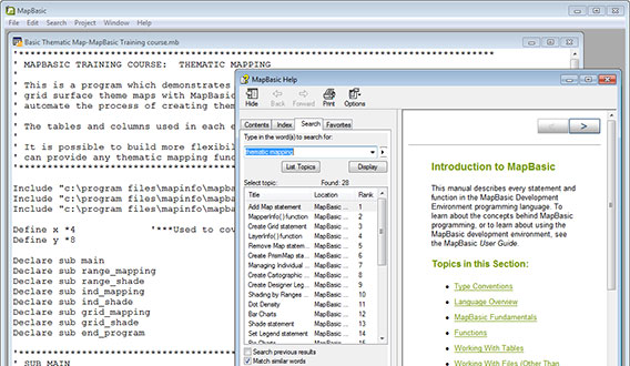
The MapBasic development environment is a freely downloadable programming language for MapInfo Professional. It can be used for any sort of customisation from simply hiding or rearranging a few menus to creating comprehensive mapping applications. Knowledge of programming is helpful but if you are new to programming, MapBasic provides extensive on-line help, documentation and sample applications.
[spb_blank_spacer height=”30px” width=”1/1″ el_position=”first last”]
Easy to learn and use
MapBasic comes with a simple development environment and includes a detailed help system. In addition a comprehensive MapBasic User’s Guide and Reference Manual are also included. A range of sample applications, from simple demonstration examples and code snippets to complex applications are also provided.
[spb_divider type=”dotted” full_width=”no” width=”1/1″ el_position=”first last”]
A range of applications
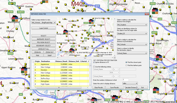
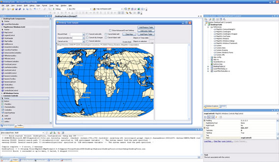
MapBasic can be used for automating repetitive tasks, adding new capabilities to MapInfo Professional or even creating specific mapping solutions for a particular use or industry. An example of adding a new capability to MapInfo Professional is the Distance Calculator tool, pictured here. The Distance Calculator is one of the many tools in MapInfo Professional’s Tool Manager.
[spb_divider type=”dotted” full_width=”no” width=”1/1″ el_position=”first last”]
Source code from the experts
Encom Discover boosts the data handling capabilities of MapInfo Professional, adding support for over one hundred additional industry-standard formats. These include advanced functionality such as image rectification and re-projection, batch ECW import, vector import and conversion (such as the GPS eXchange and Google Earth formats) and database connectivity (e.g. DataShed and AcQuire).
[spb_divider type=”dotted” full_width=”no” width=”1/1″ el_position=”first last”]
User-generated tools
MapBasic allows the development of software in popular programming languages such as C, C and Visual Basic to help automate repetitive operations in MapInfo Professional. Hundreds of third party applications have been created using this flexible development environment, many of which are offered to the MapInfo Community for free.
[spb_divider type=”dotted” full_width=”no” width=”1/1″ el_position=”first last”]
Are you a professional developer?
MapInfo MapBasic is specifically for customising MapInfo Professional. For professional developers we offer a range of developer tools for different environments and deployment models. Pictured (left/right) is MapInfo MapXtreme, a 100% .NET development kit for desktop or web based applications. We also offer a modular platform for enterprise grade applications consisting of Location Intelligence, Routing, Geocoding, Address Management and other modules.
[/spb_text_block] [/spb_tab] [/spb_tabs] [spb_text_block animation=”none” animation_delay=”0″ simplified_controls=”yes” custom_css_percentage=”no” padding_vertical=”0″ padding_horizontal=”0″ margin_vertical=”0″ custom_css=”margin-top: 0px;margin-bottom: 0px;border-top: 0px default ;border-left: 0px default ;border-right: 0px default ;border-bottom: 0px default ;padding-top: 0px;padding-left: 0px;padding-right: 0px;padding-bottom: 0px;” border_size=”0″ border_styling_global=”default” width=”1/4″ el_position=”last”]
[spb_blank_spacer height=”12px” width=”1/1″ el_position=”first last”]
[sf_button colour=”grey” type=”sf-icon-reveal” size=”standard” link=”mapinfo-training” target=”_self” icon=”fa-info-circle” dropshadow=”no” extraclass=””]MapInfo Pro Training[/sf_button]
[sf_button colour=”grey” type=”sf-icon-reveal” size=”standard” link=”https://spatialpoint.com/desktop/desktop-apps/” target=”_self” icon=”fa-info-circle” dropshadow=”no” extraclass=””]Mapping Applications[/sf_button]
[sf_button colour=”grey” type=”sf-icon-reveal” size=”standard” link=”desktop-data” target=”_self” icon=”fa-info-circle” dropshadow=”no” extraclass=””]Map & Demographic Data[/sf_button]
[/spb_text_block]