Enterprise Routing Module
Calculate routes, determine points within a boundary, and move goods from one point to another at the lowest possible cost.
Calculate routes, determine points within a boundary, and move goods from one point to another at the lowest possible cost.
Travel routing helps businesses improve location analysis and increase driving efficiency. With the Spectrum Spatial Enterprise Routing Module you can enhance delivery networks, identify key target markets and determine store network locations as part of a gravity model. You can also assess a location’s risk by its accessibility to emergency services vehicles.
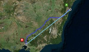
The difference between real world route travel distance/times and a straight line can be considerable. Spectrum Spatial helps organizations find the most accurate, nearest locations, taking into account physical barriers such as rivers or mountains as well as sparse transport networks in rural and semi-rural areas.
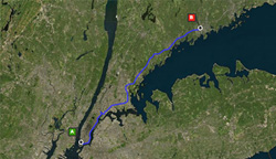
Identify route options and generate directions
The Enterprise Routing Module offers support for determining shortest and fastest routes and calculating distance or time for walking/driving networks. This enables organizations to apply business priorities within the server. Improve delivery times, conserve fuel and reduce vehicle wear with turn-by-turn directions, including way points and route geometries.
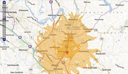
Calculate travel boundaries, times and distances
Calculate travel boundary isochrone / isodistance polygons to help your organization determine areas that can be reached within a desired time or distance along a travel network. Travel boundaries enable you to increase efficiency and provide information for targeting and service eligibility. Calculate the travel time and distances between single or multiple start and end points. You can route from one point to another point, or from one point to multiple other points, enabling multiple options to be rapidly tested.
Data Coverage
The Enterprise Routing Module offers off-the-shelf data packs including more than 25 country travel networks.
Rich Routing Capability
- Find shortest or fastest routes for walking/driving
- Find travel distance or time
- Find the nearest locations by route distance
- Generate turn-by-turn directions
- Generate route polygons
- Calculate travel boundaries
- Determine travel time/distances for one or many locations
- Apply dynamic network constraints
Integrating Routing In Applications
- Find shortest or fastest routes for walking/driving
- SOAP/REST Web Service APIs – Integrate routing into business applications using SOAP or REST Web Services
- Create and publish data flows as web services ,incorporating route based analytics via visual drag-and-drop flow diagramming in the Enterprise Designer
- Create large scale batch processes incorporating route analytics
- Augment databases with routing-derived values, adding routing insight to non-spatial systems
- Use built-in data integration to databases, web services, file and XML data sources to read input and store output results
- As part of the Spectrum Technology Platform, the Enterprise Routing Module can be combined with any module in the platform including the Enterprise Geocoding Module and the Location Intelligence Module
Travel Route Network Data Packs
- Support for >25 country road and footpath data packs
- Custom data packs are available upon request and can be used to extend geographical coverage and support specialist network configuration
Supported Operating Systems
- Microsoft Windows Server 2003 & 2008 (64bit)
- SUSE Linux 10 & 11 (64bit)
- Red Hat Enterprise Linux 5 & 6 (64bit)
- Oracle Solaris 9 & 10
- HP-UX v11iV3 (Itanium)
- AIX 6.1, 7.1