What is Magnify?
What is Magnify?
Magnify is a powerful, easy to use and economical tool that delivers accurate geo-demographic results, saving customers time and money. Magnify makes visualizing data on maps fast and easy.
Powerful – Use Magnify’s comprehensive batch and online capabilities to quickly create accurate and precise location analyses, study areas, reports and detailed Google maps.
Easy to Use – Use any contemporary browser to access Magnify’s intuitive map visualization, report and location analysis capabilities.
Economical – Use Magnify’s secure cloud-based solution to avoid expensive, complex and IT-intensive desktop software traps and maintenance.
ENHANCED MAPPING CAPABILITIES
Magnify makes visualizing data on maps fast and easy.
- Two Versions: US and Canada
- Four editions available
- User-friendly browser-agnostic interface
- Google Maps Street View, Aerial Imagery, and Points of Interest
- “My Location” and traveling capabilities for GPS-enabled devices
- Interactive map panning
- Point-and-click data display
- Customizable Microsoft® Excel reporting
- Thematic data display
- Customizable layer configuration
- User- and organization-level security
- Seamless product and data updates
- Benchmark comparison reporting
- Highly-rated customer support
POWERFUL REPORTING
Magnify has an extensive suite of the reports you need the most.
- Pitney Bowes®
- Business Summary Reports
- Consumer Expenditure Reports
- Financial Wealth Reports
- (CAN Version includes) Canada Detailed Food Expenditure Reports (CanFoodEx)
- (CAN Version includes) Canada Household Facilities and Equipment Reports (CanHFE)
- (CAN Version includes) Disposable and Discretionary Income Reports
- MicroBuild® Distribution Reports
- MicroBuildHD – Household Demographics
- MicroBuild® Distribution Reports (US Version)
- MicroBuildHE – Household Ethnicity
Use Magnify to:
- Research new and existing locations
- Quickly assess market potential
- Import and analyze your own data
- Share information with clients and colleagues
- Complement desktop software (Pitney Bowes AnySite® and MapInfo® Professional) with a cloud hosted application that reports the same information
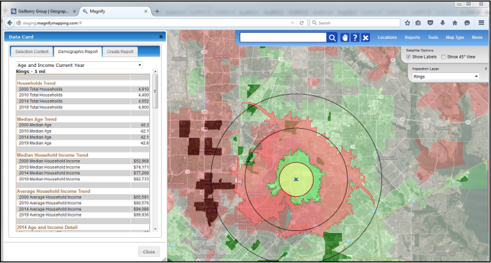
Research new & existing locations
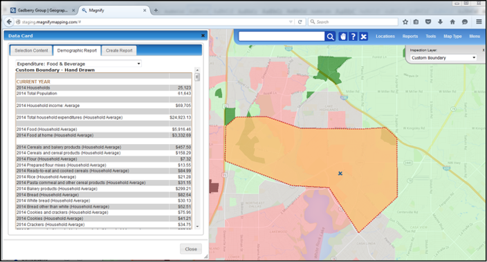
Quickly assess market potential
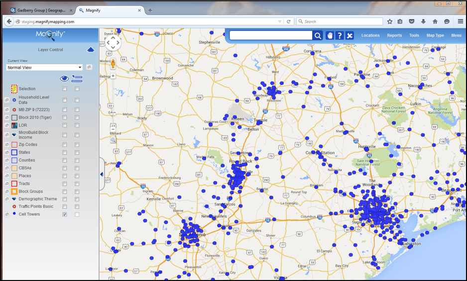
Import & analyze your own data
Magnify helps hundreds of users make better decisions…
- Commercial Real Estate
- Helps market properties to new and existing clients
- Retail
- Equips field staff with the same data corporate real estate analysts use
- Enables franchisees to find optimal locations
- Economic Development
- Helps promote local markets to incoming retailers
Powerful Advanced Features
- Batch Geocoding
- Up to 1 million address points
- TomTom Streets or Pitney Bowes Centrus Points
- Multi-Function Batch Workflow
- Multiple Study Areas
- Ring (up to three)
- Drivetime (up to three)
- Donut (up to three)
- Capture
- Comprehensive and Flexible Reports
- Multiple Study Areas
- Geography Joiner
- Join Multiple Geographies
- Create Custom Study Areas
- File Uploading and Export
- Excel (.XLSX, .CSV)
- MapInfo (.TAB)
- Esri (.SHP)
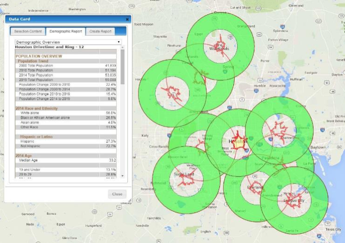

Four Editions Available
BASIC EDITION
STANDARD WITH ALL EDITIONS
Interactive Map Visualization
- Google Maps (Street, Street View, Satellite, Terrain, Aerial and Points of Interest)
- Comprehensive Map Tools (Zoom In/Out, Box Location Draw, Pan, Distance Tool)
- Personalized Map Preferences (Layer, Point, Polygon, Label)
- Toggle On/Off Layer Control
- Location Manager
- Drop Location on Map
- Static Blue Dot for Current Location
- Single Address Search with Static Location Marker (Google Search)
- Create Single Points and Ring Study Areas
- Custom Hand-Drawn Study Area
- Comprehensive Thematic Layers
File and Content Management
- Upload and View AnySite (.SIT) Files
Reports
- Microsoft Excel Format (.XLSX, .CSV)
- Customizable Report Template
- Extensive List of Standard Reports
BUSINESS EDITION
INCLUDES BASIC EDITION PLUS
Interactive Map Visualization
- Create Drivetime Study Areas
- Banded (Repeating) Study Area Style for Rings or Drivetimes
- Traveling Blue Dot for Current Location
File and Core Content Management
- File Upload Manager – Upload Data for Visualization (.XLSX, .CSV, .TAB, .SHP)
- File Download Manager – Download Geographic Data (.CSV, .TAB, .SHP)
- Batch Geocode and Save as a Layer Workflow
- Publish custom layers to other Magnify users (sold separately)
Reports
- Location Reports
PROFESSIONAL EDITION
INCLUDES BUSINESS EDITION PLUS
Interactive Map Visualization
- Layer Search – Quickly Zoom to Location
- Geography Joiner – Easily create Custom Boundaries on the Map
File and Core Content Management
- File Download Manager – Download Demographic Data (.CSV, .TAB, .SHP)
- Create Donut and Capture Study Areas
- Comprehensive Batch Workflow, including
- Geocode (Large) Including Download of Geographic Data
- Geocode, Save as a Layer, Create Study Area
- Multi-Action Workflow – Geocode, Save as a Layer, Study Area, Reports
Reports
- Premium Benchmark and Hi-Resolution Map Reports
- Flexible and Comprehensive Demographic Workflow Reports
VIEWER EDITION
AVAILABLE AS PURCHASE WITH BUSINESS OR PROFESSIONAL EDITION
- The perfect companion edition for users who have limited GIS experience
- View and take action on published content for better business decisions
- Comprehensive Map Visualization capability
- Does not include Demographic or Geographic data (boundaries)

