You are on the Street-Level Routing Page in the Software-as-a-Service (SaaS) Section….
[dipi_button_grid flex_direction=”row” _builder_version=”4.16″ _module_preset=”default” text_style_font=”Molengo|||||on|||” text_style_text_align=”center” text_style_font_size=”14px” background_color=”rgba(0,0,0,0)” transform_translate=”8px|-25px” transform_translate_linked=”off” max_height=”306px” custom_margin=”||||false|false” custom_padding=”||||false|false” animation_style=”fade” animation_duration=”400ms” border_color_all=”#edf000″ saved_tabs=”all” locked=”off” global_colors_info=”{}”][dipi_button_grid_child button_id=”SaaS Overview” button_text=”SaaS Overview” button_link=”https://spatialpoint.com/saas-ondemand/” _builder_version=”4.16″ _module_preset=”default” text_style_font=”Molengo|||||on|||” text_style_font_size=”26px” background_color=”rgba(0,0,0,0)” background_enable_color=”on” custom_button=”on” button_text_color=”#ffffff” button_bg_color=”#e02b20″ button_border_color=”#d6d6d6″ button_border_radius=”11px” button_font=”Roboto||||||||” button_use_icon=”on” button_icon=”%%24%%” button_icon_color=”#ffffff” button_on_hover=”on” custom_margin=”|0px|||false|false” custom_padding=”||||false|false” border_width_all=”1px” border_color_all=”rgba(0,0,0,0)” box_shadow_style_button=”preset1″ global_colors_info=”{}”][/dipi_button_grid_child][dipi_button_grid_child button_id=”Geocoding” button_text=”Geocoding” button_link=”https://spatialpoint.com/1-geocoding/” _builder_version=”4.16″ _module_preset=”default” text_style_font=”Molengo|||||on|||” text_style_font_size=”26px” background_color=”rgba(0,0,0,0)” background_enable_color=”on” custom_button=”on” button_text_color=”#ffffff” button_bg_color=”#e02b20″ button_border_color=”#d6d6d6″ button_border_radius=”11px” button_font=”Roboto||||||||” button_use_icon=”on” button_icon=”%%24%%” button_icon_color=”#ffffff” button_on_hover=”on” custom_margin=”|0px|||false|false” custom_padding=”||||false|false” border_width_all=”1px” border_color_all=”rgba(0,0,0,0)” box_shadow_style_button=”preset1″ global_colors_info=”{}”][/dipi_button_grid_child][dipi_button_grid_child button_id=”AddressVal” button_text=”Address Validation & Correction” button_link=”https://spatialpoint.com/address-validation/” _builder_version=”4.16″ _module_preset=”default” text_style_font=”Molengo|||||on|||” text_style_font_size=”26px” background_color=”rgba(0,0,0,0)” background_enable_color=”on” custom_button=”on” button_text_color=”#ffffff” button_bg_color=”#e02b20″ button_border_color=”#d6d6d6″ button_border_radius=”11px” button_font=”Roboto||||||||” button_use_icon=”on” button_icon=”%%24%%” button_icon_color=”#ffffff” button_on_hover=”on” custom_margin=”|0px|||false|false” custom_padding=”||||false|false” border_width_all=”1px” border_color_all=”rgba(0,0,0,0)” box_shadow_style_button=”preset1″ global_colors_info=”{}”][/dipi_button_grid_child][dipi_button_grid_child button_id=”ReverseGeocoding” button_text=”Reverse Geocoding” button_link=”https://spatialpoint.com/3-reverse-geocoding/” _builder_version=”4.16″ _module_preset=”default” text_style_font=”Molengo|||||on|||” text_style_font_size=”26px” background_color=”rgba(0,0,0,0)” background_enable_color=”on” custom_button=”on” button_text_color=”#ffffff” button_bg_color=”#e02b20″ button_border_color=”#d6d6d6″ button_border_radius=”11px” button_font=”Roboto||||||||” button_use_icon=”on” button_icon=”%%24%%” button_icon_color=”#ffffff” button_on_hover=”on” custom_margin=”|0px|||false|false” custom_padding=”||||false|false” border_width_all=”1px” border_color_all=”rgba(0,0,0,0)” box_shadow_style_button=”preset1″ global_colors_info=”{}”][/dipi_button_grid_child][dipi_button_grid_child button_id=”Street-Level Routing” button_text=”Street-Level Routing” button_link=”https://spatialpoint.com/4-street-level-routing/” _builder_version=”4.16″ _module_preset=”default” text_style_font=”Molengo|||||on|||” text_style_font_size=”26px” background_color=”rgba(0,0,0,0)” background_enable_color=”on” custom_button=”on” button_text_color=”#ffffff” button_bg_color=”#fc9569″ button_border_color=”#d6d6d6″ button_border_radius=”11px” button_font=”Roboto||||||||” button_use_icon=”on” button_icon=”%%24%%” button_icon_color=”#ffffff” button_on_hover=”on” custom_margin=”|0px|||false|false” custom_padding=”||||false|false” border_width_all=”1px” border_color_all=”rgba(0,0,0,0)” box_shadow_style_button=”preset1″ global_colors_info=”{}”][/dipi_button_grid_child][dipi_button_grid_child button_id=”InsuranceRisk” button_text=”Insurance Risk Services” button_link=”https://spatialpoint.com/insurance-risk-services/” _builder_version=”4.16″ _module_preset=”default” text_style_font=”Molengo|||||on|||” text_style_font_size=”26px” background_color=”rgba(0,0,0,0)” background_enable_color=”on” custom_button=”on” button_text_color=”#ffffff” button_bg_color=”#e02b20″ button_border_color=”#d6d6d6″ button_border_radius=”11px” button_font=”Roboto||||||||” button_use_icon=”on” button_icon=”%%24%%” button_icon_color=”#ffffff” button_on_hover=”on” custom_margin=”|0px|||false|false” custom_padding=”||||false|false” border_width_all=”1px” border_color_all=”rgba(0,0,0,0)” box_shadow_style_button=”preset1″ global_colors_info=”{}”][/dipi_button_grid_child][dipi_button_grid_child button_id=”PSAP911″ button_text=”911/E911/PSAP” button_link=”https://spatialpoint.com/6-911-e911-psap/” _builder_version=”4.16″ _module_preset=”default” text_style_font=”Molengo|||||on|||” text_style_font_size=”26px” background_color=”rgba(0,0,0,0)” background_enable_color=”on” custom_button=”on” button_text_color=”#ffffff” button_bg_color=”#e02b20″ button_border_color=”#d6d6d6″ button_border_radius=”11px” button_font=”Roboto||||||||” button_use_icon=”on” button_icon=”%%24%%” button_icon_color=”#ffffff” button_on_hover=”on” custom_margin=”|0px|||false|false” custom_padding=”||||false|false” border_width_all=”1px” border_color_all=”rgba(0,0,0,0)” box_shadow_style_button=”preset1″ global_colors_info=”{}”][/dipi_button_grid_child][dipi_button_grid_child button_id=”Tax Jurisdiction ” button_text=”Tax Jurisdiction ” button_link=”https://spatialpoint.com/7-tax-jurisdiction/” _builder_version=”4.16″ _module_preset=”default” text_style_font=”Molengo|||||on|||” text_style_font_size=”26px” background_color=”rgba(0,0,0,0)” background_enable_color=”on” custom_button=”on” button_text_color=”#ffffff” button_bg_color=”#e02b20″ button_border_color=”#d6d6d6″ button_border_radius=”11px” button_font=”Roboto||||||||” button_use_icon=”on” button_icon=”%%24%%” button_icon_color=”#ffffff” button_on_hover=”on” custom_margin=”|0px|||false|false” custom_padding=”||||false|false” border_width_all=”1px” border_color_all=”rgba(0,0,0,0)” box_shadow_style_button=”preset1″ global_colors_info=”{}”][/dipi_button_grid_child][dipi_button_grid_child button_id=”Specialty” button_text=”Specialty” button_link=”https://spatialpoint.com/8-specialty/” _builder_version=”4.16″ _module_preset=”default” text_style_font=”Molengo|||||on|||” text_style_font_size=”26px” background_color=”rgba(0,0,0,0)” background_enable_color=”on” custom_button=”on” button_text_color=”#ffffff” button_bg_color=”#e02b20″ button_border_color=”#d6d6d6″ button_border_radius=”11px” button_font=”Roboto||||||||” button_use_icon=”on” button_icon=”%%24%%” button_icon_color=”#ffffff” button_on_hover=”on” custom_margin=”|0px|||false|false” custom_padding=”||||false|false” border_width_all=”1px” border_color_all=”rgba(0,0,0,0)” box_shadow_style_button=”preset1″ global_colors_info=”{}”][/dipi_button_grid_child][/dipi_button_grid]
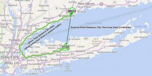
 points, either fastest or shortest. Specified road types can be favored, avoided or given different preferences (e.g. high, low, medium.) You have control over speeds used by road type – by percentage or absolute value. Historical traffic speeds can be used (e.g. AMPeak, PMPeak, OffPeak and Night.)
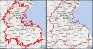
 Compare at 10 mile radius around a location vs a 10 minute drive. The radius is obviously a circle but the 10-minute drive takes into account the road network and road speed limits. A drive time shape is rarely a circle. You have control over speeds used by road type – by percentage or absolute value. Historical traffic speeds can be used (e.g. AMPeak, PMPeak, OffPeak and Night.) In some cases, island and donut shapes can be returned. You have the option to control whether these are returned.
