SpatialPoint Data Primer
What Is “Data” And Why Do I Need It?
Why do I need data?
Unlike most other types of software, mapping and spatial software often require specific data products other than your own data.
Point, Boundary and Line Data
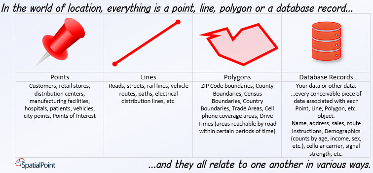
In typical business mapping, these data products are generally “point data” or “boundary data.” For example, you can license a database of ZIP Code points, which is really a list of every US ZIP Code and the coordinates of where each one is at. You can open it in a spreadsheet.
You can also license a database of ZIP Code boundaries, which includes coordinates for each part (node) of the shape of each ZIP Code. Boundary data is made up of polygons. These boundary databases are usually much larger than point data because there could be hundreds or thousands of nodes for each ZIP Code. When the software draws a point data table, all you can see are points. When the software draws a ZIP Code boundary, you see the actual shape.
Besides ZIP Codes, some other databases that come in point or boundary form are Cities (city points or City boundaries), Airports (points that represent the location of the airport) or boundaries (shapes that describe the land covered by the airport.) There are many more.
There is another type besides points or boundaries used in business: lines. An example of a line data product is streets and roads. You might need these for your own routing or to display on maps. Since these data products are databases, you can do all sorts of things with them. For example, you can only work with (or display) certain road types. With some products, traffic counts, volumes and average speeds by time-of-day are available.
Associated with each object are fields of data. You can think of this in a few ways: a database with rows and columns of data with objects thought of as being in additional columns. Most database tables have one object column with many data typical text, numeric, time, etc. data fields.
The other way to think about it is that there are objects, such as ZIP Codes, and associated with each ZIP Code are many fields – again, typical text, numeric, time, etc. fields.
You don’t necessary need a mapping system because some databases (SQL Server for example) understand spatial data and it’s programmed to know how to operate with these data types.
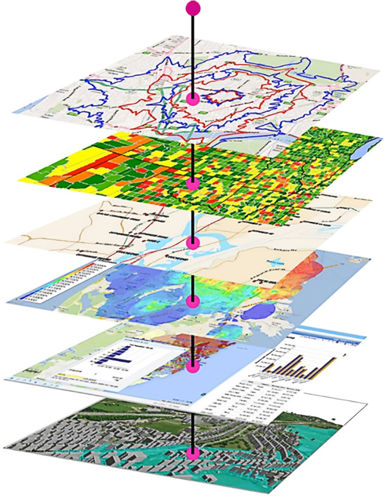
There are many other data types, such as imagery, but the main types in business mapping are points, boundaries (polygons) and lines.
Go to a specific Data Product on the Data Product Page:
Jump to Postal Data
Jump to Administrative/Census Reference Data
Jump to Community Boundaries
Jump to World Boundaries
Jump to Demographic/Psychographic Data
Jump to Points of Interest Data
Jump to Streets and Road Network Data
Jump to Parcels, Buildings and Address Fabric
Jump to Risk Assessment Data
Jump to Telecommunications Data
Jump to Wireless Coverage Data
Jump to PSAP (911/E911) Data
Can I Mix and Match Data From Different Vendors?
It is possible to that you will run into major problems because the maps may have been created from different sources and the “geography” of the objects may not line up. A common example is requiring ZIP Code boundaries that lineup with the street maps and County boundaries. Many of the County boundary databases will not line up with the ZIP Code boundaries. In this case, the ZIP Codes might cross the County boundaries in many places. Lower quality ZIP Code data may not line up with the Street maps, too. This issue is also present with many other databases. The data we license generally comes from sources that take care in aligning the various datasets. In all cases and especially for more specialized datasets, we will help you evaluate the marketplace.
I Have Google or Bing Maps, Why Do I Need Other Data?
Google and Bing generally display images and don’t include the underlying data. Also, there are many datasets that aren’t included in Google or Bing Maps. Even though Google and Bing display streets and roads, you may still need a Street database. In this case, the street data is generally made with lines, not points or boundaries.
What Data Is Available Outside the US?
While some data products are US-only, many data products are available for much of the rest of the world. World Reference Data is specifically about the entire world. Examples are World Boundaries and World Points.
Can I Access This Data As A Service (DaaS)?
Yes! Some of the data can be used as part of prebuilt processes. For example, while you can license the raw data to do your own geocoding, we offer geocoding services that use many of these datasets and handle all of the complexities Also, we can include these datasets in what are known as Dataflows that are provided as REST (or SOAP) services and that can greatly simplify your programming efforts. There are many ways that the data and services-that-use-the-data can be delivered to you.
What is Data Enrichment?
Data Enrichment is augmenting your own data with these spatial datasets. We can also eliminate many spatial database operations by pre-matching your data with these datasets. For example, if you are an insurance company, you can automatically append various risk factors to your book of business on a regular basis or, of course, on demand. Your systems will have immediate access to the attributes you need for each property. Some businesses regularly geocode every address in the country and append the key variables they need – so their systems are incredibly responsive.
SpatialPoint can help you decide what is right.
What Type Of Software Can Use This Data?
Typically mapping software such as MapInfo™ or Esri™, or in databases such as Microsoft SQL Server™, or in systems such as Alteryx™ or Tableau™. But many datasets can be used in Excel™, too.
Here’s a larger list (copyrights are owned by their holders): Esri, Tableau, R Statistical Data, Autodesk, Microsoft SQL, Microsoft Azure SQL, Microsoft Dynamics, Oracle, Amazon AWS (DynamoDB, Aurora, RDS, Redshift ElasiCache, Keyspaces, Neptune, Timestream, QLDB, etc.), Hadoop DFS,, MariaDB, Kinetica, PostGIS, PostgressSQL, Excel, MySQL, IBM Db2, IBM Informix, Netezza, SAP HANA, Teradata, Aspectum, Cityworks, ERDAS, Intergraph, Smallworld, Golden Software, MapBox, etc.
What Are Some Of The Things To Consider About Data?
How Can SpatialPoint Help?
We are experts. We have decades of experience working with many different datasets. Most organizations expect quality results and choosing the right ingredients is important. It is easy to mismatch datasets that create downstream problems. We’ll help you navigate through this process.


